Navigate the NYC subway seamlessly with “Google Maps for NYC Subway.” Stay informed about train updates, closures, and delays for a stress-free commute in the Big Apple.
If you live in New York City, you will appreciate what Google Maps has accomplished. Google Maps for New York City has been updated with tube updates. So, if a train isn’t running, has been closed, or isn’t on time, you can see it on your Google Maps app. Like our popular guides on how to change voice on Google Maps and Change maps from walking to driving, we’re covering this article for our NYC rea
With Real Estate listings to help us find a place, Street View to help us scope out the neighborhood, directions to help us find our broker, and local search to find nearby amenities, the only thing we needed was another source to see where the extensive subway lines ran. Until now, that is!
Thanks to service updates and delayed information, Google Maps users in New York City will always get where they need to go. Google Maps now includes NYC Subway transit routes. The Google Maps for NYC Subway team has added tube maps to the site.
When you’re in New York and want to get that perfect hot dog or a slightly less greasy slice of pizza, Google can tell you which tube to take. This new feature will be handy for users of mobile apps no more lost tourists. Google Maps recently added a transit guide for the New York City area.
This guide adds tube locations to a Google Map of New York City and gives users step-by-step directions to the nearest tube station.
Here are a few steps on How to Use Google Maps for NYC Subways as shown below:
Google Maps for NYC Subway
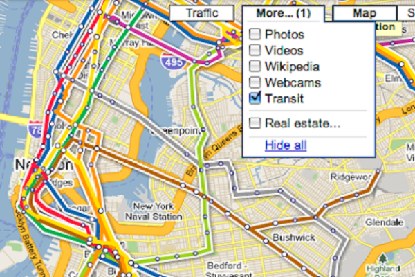
It used to be that the only way to see digital maps of the New York subway system was to use an overlay. VGMap still has an excellent subway overlay; however, other sites are becoming obsolete now that Google is on board with the idea. With the Google Maps feature, you only have to click the More menu and checkbox transit to enable Google subway maps. All of the subway routes will show up as easy-to-see bright colored lines.
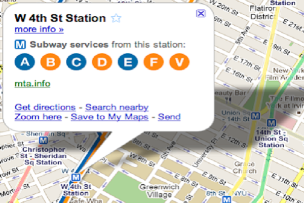
Google shows you not only the lines but also each stop. The maps also indicate which services are available at each station and whether they are operational. New York was not the only city to receive a map update this year. The Los Angeles Metro and light rail systems were added to maps in July. Public transportation can be intimidating at times, especially in unfamiliar territory. Hopefully, this Google update and the transit update will eliminate the possibility of getting lost.
NYC Map with Interesting Features
This new Google update is available right now. If you live in the New York City area, you should be able to access Google Maps Transit information immediately.
Google hasn’t added transit information to any other cities yet, but let’s hope the NYC experiment goes well enough that Google feels compelled to add more cities to the list. This Google update is not only good news for Google Maps users, but it is also another way for Google to gain a competitive advantage. Knowing which bridges are closed and which roads are blocked during rush hour is applicable, similar to transit updates.
For one thing, it’s nearly impossible to find anything related to North Korea on Google Maps. This shouldn’t come as a surprise since North Korea is highly guarded and not part of the visible world. Google Maps is also unavailable in other parts of the world for unknown reasons. However, Google Maps has many excellent features you can view and use.
For example, you can use Google Maps to create your map. You can use the tool to map out any area and even post the map on your website. You can also edit Google Maps, which is a fun feature. If you notice something isn’t quite right, notify Google by entering editing information. Finally, you can view traffic conditions based on your location.


